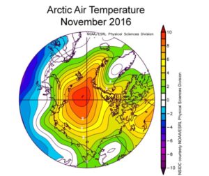
Fall 2016, being extremely mild and pleasant, in the midwest this period has turned out to be one of the warmest regions, until the week of Thanksgiving, on November 24th, when the region saw 1 to 2 inches of snow on thanksgiving eve. The snow didn’t stay, with 40 to 50 degree temperatures banking around sunday to monday, during the last week of November, 2016. Amazing warmth, in the Twin Cities in Minnesota, on November 28th, with highs in the 50s. This trend was ended promptly with cooler temperatures on the day of December 1st, and it will be chased away, with cold temperatures until Christimas Day.
Polar Ice and Fall 2016 Warmth
The polar ice in the northern region of the pole, did not thicken as usual this fall, and in fact, is the smallest circumference ever recorded. Due to the global ocean warmth, record high temperatures around the northern pole, and the La Nina effect in the southern pacific ocean, the cataclysm of these three warm events has created another event, very little polar ice around the southern pole as well. Huge normally frozen areas, larger than most land masses in the northern region have melted. The warm temperatures are proving to be quite alarming, so having a cold spell exist and stay put in the midwest is a good thing.
Fall 2016 2nd warmest for Minnesota, Warmest for 5 state region
Normal highs in Minnesota in November are around freezing, 32 degrees. Recorded highs ranged from 65 to 22 degrees, marking a fall that did not seem to follow normal patterns of La Nina. This information could mean, that the La Lina kept the region cooler than an El Nino Year, or even a regular sea temperature year…this could be a good indication of how much these events change temperatures vs. precipitation.
Fall 2016 Soil Temperature
In the midwest, the soil temperature did not hit freezing until December 5th, and was averaging around 38 to 40 degrees until December 1st. The soil thoroughly froze to a depth of 5 inches on December 8th, with the average high air temperature of 20 degrees. The advance of a strong low across the region has ushered in the winter weather, which will stick around now until the end of December. Most often, once the soil has frozen to the 5-6 inch depth, the cooler average temperature is more common; a soil temperature is often a good indicator of snow vs. rain in a 3 day model forecast.
With the advance of the next system out of the northwest, the midwest will see 6 inches of snow over the next 48 hours, with most of that, sticking around until another front shows itself around December 18th. The chance of a white christmas are very good for the midwest, and most of the country in 2016.

